The following information has been shared by the Emergency Manager on Duty for Huntingdonshire District Council on 4th January 2024
We have sadly, had some updated information regarding the forecast rain likely to impact the district and specifically the river levels. We have had a Flood Advisory Call with the Environment Agency and there will be a Severe Weather call at 4pm this afternoon to ensure all partners are prepared and on standby in case of escalation overnight. I hope the following information will provide you with an idea of the current situation and possible risk so we can support our communities to be prepared.
The Flood Guidance Statement
The statement for today (04/01/24) and tomorrow is yellow for a low likelihood of significant river flooding impacts in the Cambridgeshire and Peterborough area.
View the latest Flood Guidance Statement
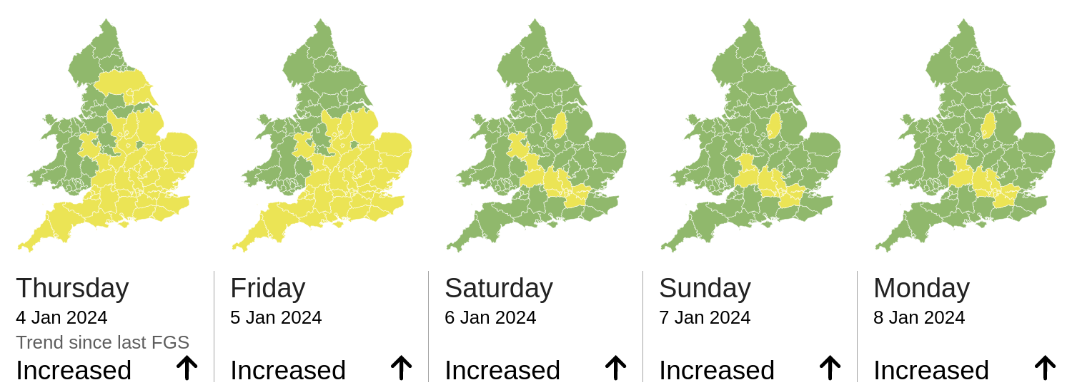
Significant inland flooding impacts are possible today (Thursday) and on Friday in parts of the Midlands and the South and East of England. The overall flood risk is LOW.
Widespread, rainfall is forecast this evening into tomorrow morning. Most of the rain is expected to fall within a 6hr period (18:00-00:00) with locally heavy bursts possible. Rainfall totals of 19mm are expected, there is low confidence over the exact locations. The local forecast is for 10-20mm of rain.
River levels remain high. We are expecting them to remain high and rise with the forecasted rainfall. Continued localised river flooding impacts are probable today and tomorrow as the rainwater enters the river to flow out via the washes. Surface water flooding impacts are probable and could include localised flooding from urban and fast responding watercourses/catchments, drains, channels and flooding from overland flow. The catchment is saturated, and rivers are responding faster than normal.
Current Alerts
1 Flood Alert
Flood warning for River Great Ouse at Eaton Socon, Eynesbury, Eaton Ford, and St Neots – updated 12:17pm on 4 January 2024 – Flooding Expected – Act:turn off gas, water and electricity; move things upstairs or to safety; move family, pets and car to safety
This flood warning has been updated to reflect the high current level and potential for rain water to increase it further. The official guidance for properties close to the river:
River levels are currently high, but steady following heavy rainfall from Storm Henk. Flooding is expected. Areas most at risk are School Lane and Wheatsheaf Road in Eaton Socon, Wren Walk, Hardwick Road and St Marys Street in Eynesbury, St Neots Road, Mill Hill Road and Cross Hall Road in Eaton Ford, High Street, Priory Road, New Street, Hawthorn Road and Leys Road in St Neots. The forecast is for more rainfall this evening, and into Friday. River levels will remain high. Move parked cars out of flood risk areas and avoid walking or driving through flood water. We are monitoring the situation. We will update this message by 6pm today, 04/01/2024.
Flood warning area: School Lane and Wheatsheaf Road in Eaton Socon, Wren Walk, Hardwick Road and St Marys Street in Eynesbury, St Neots Road, Mill Hill Road and Cross Hall Road in Eaton Ford, High Street, Priory Road, New Street, Hawthorn Road and Leys Road in St Neots.
3 flood alerts in our district (Flooding is possible)
These remain benefitting from a steadying and current slow reduction in height.
- Alconbury Brook in CambridgeshireUpdated 8:49am on 4 January 2024
- River Great Ouse in Cambridgeshire from Brampton to EarithUpdated 8:48am on 4 January 2024
- River Great Ouse in Central Bedfordshire, Beds Borough and Cambridgeshire from Wyboston to BramptonUpdated 9:13am on 4 January 2024
1 flood warning removed in the last 24 hours
- Alconbury Brook at Hamerton, Alconbury Weston, Alconbury, Little Stukeley and Brampton Removed at 4:36pm on 3 January 2024
Please note this may be re-instated depending upon the location of the rain fall.
Local Met Office Weather Forecast
Although fine today – rain is expected to arrive from the south west from late afternoon. Pulses of rain then continue overnight into Friday morning. Rainfall totals of 10 to 20mm could fall widely – and although locally we could see 30 to 40mm, where exactly these heavier pulses falls remains unclear at this stage.
Ground remains saturated so surface water flooding could readily occur in many areas – and an updated Yellow Warning for Rain has been issued for our region.
The warning now brings a Low Likelihood of Medium Impacts, which means:
- homes and businesses could be flooded, causing damage to some buildings
- delays or cancellations to train and bus services are possible
- spray and flooding could lead to difficult driving conditions and some road closures
- some communities may be cut off by flooded roads
- possible power cuts and loss of other services to some homes and businesses
This warning is valid from 1200 today until 0300 Friday – and covers a wide area of England. For our region, the rainfall with risk of impacts is from this evening, then overnight and continuing into Friday. Meanwhile, strong winds are possible tonight and into early tomorrow, with gusts of 30 to 40mph in places and blowing from a north west then north easterly direction, as low pressure moves to the east. Daytime Friday will see rain gradually become more showery and lighter, as a north easterly wind also eases down. From this weekend and into next week a change as high pressure finally dominates our weather, bringing much drier – and colder weather. Winds from the north east or east will bring a different feel, with cold days and a risk of overnight frost and ice. A few, possibly wintry, showers could get blown in from off the North Sea at times.
Current River Levels
The chart below shows the current river levels and the direction of travel in terms of height, as briefed by the environment Agency, it is felt that all things remaining the same the current St Neots level has peaked as the previous rainfall from the river catchment has progressed along the river. Future levels will however respond to the rainfall predicted from 6pm. There is still a degree of uncertainty about where the rain will fall, only when this is known will any predicted river impact be known.
District Council Response
As you know we take our coordination role in relation to any potential emergency incident in our area incredibly seriously. I remain our Duty officer at present, and we have already issued warning communications to our residents regarding the weather warning, making arrangements to ensure our comms and customer service teams continue to provide appropriate guidance to the public.
- Our 24/7 Emergency response via CCTV team have been briefed.
- Early warning communications for St Neots to flag the changed flood alert completed
- Warning communications regarding use of our Riverside car parks issued.
- Website updated.
- Operational teams prepared to support clear up from Monday once the weather has passed through and the river levels have fallen.
- The emergency services (including fire and police) have confirmed no call outs to emergency situations at present.
If there are early signs of issues, and you are aware of problems that need addressing, please use the attached flow chart to request the support you need from the relevant organisations. Proactive action is always better than response in relation to such issues, so if you are concerned please act.
We will do all we can to try and protect our residents and communities, however, the district Council has extremely limited powers and consequently very few resources to deploy in relation to flooding over and above playing a coordination role. Put simply HDC is not in a position to provide protection for private properties in the event of flooding. However, coordination and communication remains key and we will do all we can to support in this area.
As previously stated the role of individuals in any situation like this is critical, and we would encourage you to promote the EA service for residents to sign up for proactive flood alerts relating to their property.
Information on current flood alerts in place, or called subsequently can be found here.
We will of course extend this information again to our parishes and would welcome any opportunities you have to do the same so we can help our residents to be as prepared as they can be.
Looking Ahead
- There is a severe Weather Teleconference at 4pm to ensure all emergency responders are prepared for this evening in case of incident. I will provide an update following this meeting.
- The Environment Agency has also scheduled a Flood Advisory Meeting for tomorrow morning to review the river impacts and flow following the rainfall.
- Once more information about the location and extent of rainfall is known additional information regarding the river levels and potential impacts will follow